We, three septuagenarian veterans of sailboat cruising in Maine, were curious what a power-boat charter would be like. So, when we saw a four-day window in Ellis Charter’s schedule, we thought that would be a perfect opportunity to sample the experience. We are accustomed to sailing at speeds between four and six knots while steering clear of lobster pot buoys, so the prospect of cruising at 15 knots without needing to be wary of pot buoys was very appealing. It would allow us to get between destinations expeditiously and enjoy exploring the many shores and hiking trails of outlying Maine islands.
Our cruise aboard “Hathor”, an Ellis 36 Express Cruiser, brought us much sunny weather to enjoy our shore excursions, punctuated with periods of rain, fog, strong winds, and choppy seas as we moved between stops. We welcomed the sense of shelter and robustness that Hathor provides, compared to the exposure to the elements aboard a sailboat. In our 96 hours with the boat, we made stops in the following places, as described further:
• Lunt Harbor, Frenchboro/Long Island (mooring) – pictured below
• Burnt Coat Harbor, Swans Island (mooring)
• Southern Harbor, North Haven Island (anchor)
• Duck Harbor, Isle au Haut (anchor)
• Seal Bay, Vinalhaven (anchor)
• Merchant Harbor, Merchant and Harbor Islands (anchor)
• Islesford, Little Cranberry Island (mooring)
• Northeast Harbor, MDI (dock)
• Southwest Harbor, MDI (dock)
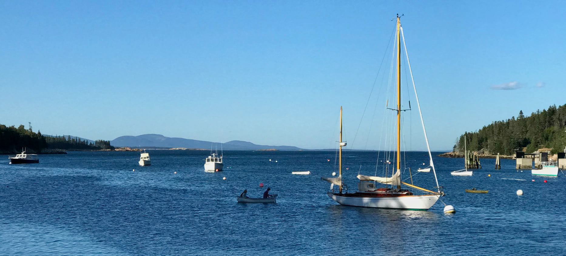
Looking back at Mount Desert Island from Lunts Harbor – Stop #1
Day 1: After a boat-handling check-out from an Ellis technician that covered docking and picking up moorings, we left Southwest Harbor on Mount Desert Island for Frenchboro, Long Island in the early afternoon. We settled on 2500 rpm to yield 15 knots at a comfortable noise level as our cruise speed. In less than an hour, we arrived at our destination in Lunt Harbor where we picked up a rental mooring. The same passage would have taken at least four hours of tacking against the tide in a sailboat! Lunt’s Harbor on Frenchburo Island

Ashore, we followed the trail to Little Beach and returned via Big Beach (photo), hiking through Maine Coast Heritage Trust land. Upon our return, we sampled an excellent home-made blueberry pie at Lunt’s Dockside Deli, which serves dinner and breakfast with superb blueberry muffins.
We found the $25-moorings at the entrance to Lunt Harbor to be rolling too much for overnighting, so we relocated to Burnt Coat Harbor on the southern side of Swans Island, where we took up a rental mooring ($25 on the honor system). It took only a few minutes to relocate—a big advantage of a semi-planing powerboat, like Hathor!
Day 2: The next day, we awoke to a forecast of rain and fog. So, we decided to take advantage of exploring the shores of Burnt Coat Harbor before the weather struck. We landed at a dock on the south side and walked out and back to the lighthouse at Hockamock Point via a very nice trail system at the entrance to the lighthouse precinct. We could see on our weather radar app that the arrival of rain would allow us to explore the north-eastern shore of the harbor, so we went across the harbor to Minturn, where a substantial dock provides space for visiting dinghies. We took the first road to the right to visit the quarry—now a community swimming hole—and to enjoy the vistas past Hockamock Point.

Sunrise on the Burnt Coat Harbor lobster fleet
View from the quarry at Minturn, south past Hockamock Point
The rain began as we climbed back aboard Hathor, where I plotted a route on the Garmin 7612 xsvTM chart plotter. I had watched a training video for the unit and found it extremely easy to use: Simply touch and confirm your next destination and then move the intervening line away from obstacles to make turns between route legs, resulting in a prominent magenta route line and information about your progress on each leg, as you follow it.

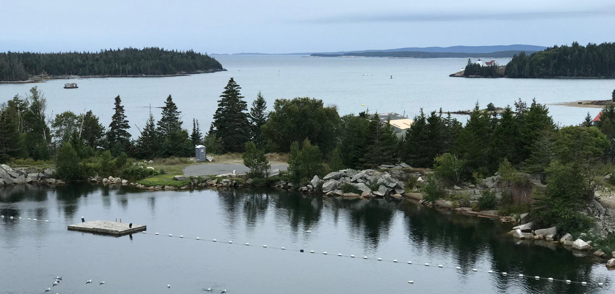
We dropped the mooring and followed the programmed route along the southern shore of Swans Island into pot-buoy-infested Jericho Bay, through Merchants Row, across East Penobscot Bay (slowing to 10 knots in fog with the searchlight turned on to increase Hathor’s visibility while monitoring the radar), into the Fox Island Thoroughfare to find a sheltered anchorage in Southern Harbor (photo), which permits a walk into the town of North Haven from Thayer’s Y-Knot Boatyard. The trip took under two hours. We decided that it was too drippy and foggy to go into town, so we just enjoyed the comfort of Hathor’s shelter.
Day 3: We awoke to post-cold-front clearing skies, but a forecast of strong winds in the afternoon. So, we departed early for Duck Harbor on Isle au Haut, retracing our route through the Fox Island Thoroughfare to ensure a timely arrival, rather than completing our planned circumnavigation of Vinalhaven Island via the Narrows. Duck Harbor is the gateway to some of the most beautiful wilderness hikes in the Acadia National Park system (SEE MAP). It is narrow and exposed to the west and southwest. Holding is good, but overnighters often put out stern anchors to deal with the limited swing room. We arrived near high tide with the prospect of a steady wind from the west-northwest, so we saw that one anchor would suffice.
 After monitoring the anchor for swing and security, we took a walk around the Harbor to Ebans Head, checking back on the boat’s status. Satisfied, we continued north along a marked trail and returned via a service road. Seeing that the boat was still safely anchored, we ascended Duck Harbor Mountain, which offers magnificent views the breadth of East Penobscot Bay. I encouraged my companions to take the Western Ear to Cliff Trail hike, while I returned to the boat to monitor the effects of a falling tide and rising winds. When they returned, waves were entering the harbor, propelled by gusty winds, as forecasted. Seeking a calmer overnight spot, we decided between beam seas up to Billings Marine in Stonington and head-on seas to Seal Bay in Vinalhaven, we opted for the latter, as we raised anchor and departed into the wind and waves.

Ebans Head seen from the trail

View to Vinalhaven and Stonington from Duck Harbor Mountain
Departing Duck Harbor, we quickly found that our previous cruising speeds would result in blinding spray over the bow, so we throttled back to eight knots, which still bounced in the choppy waves and required vigilance to avoid pot buoys and toggles. As we approached the lee of Vinalhaven, we progressively increased our speed in the diminished waves.
At anchor, we enjoyed the view from our rear deck in the calm pool of Seal Bay, where we watched the nearly full moon rise in the east. Seal Bay harbored many other boats seeking shelter from the wind and waves. The sailors aboard two Hinckleys exulted about the fun they had enjoyed sailing that day. When we raised the anchor the next day, we had to wash the mud off the chain and anchor as they came up.
 Day 4: With warm, sunny weather ahead, we plotted a course to Merchant Harbor on the north side of Merchant Island to make two wet landings with the dinghy on Merchant Island and on Harbor Island (pictured), which defines the harbor. Upon arrival, we saw that the mid-harbor mooring was occupied, so we anchored in 20 feet at low tide near the head of the harbor. In preparation for the wet landings (no dock available), we found about 50 feet of line, which we attached to a smaller line that fit through the eye of the spare anchor—this to allow the dinghy to drift downwind in the water, secured by the anchor ashore, and not get stranded as the tide went out, thus creating the need to carry the dinghy and its heavy motor back into the water. Hathor’s Fortress anchor is extremely light and easy to use for this purpose. We set the angle of the outboard motor for shallow draft, so it wouldn’t hit bottom as we approached the shore. The beach and shore of the two islands are wonderfully sculptural and populated by glacier-borne rocks from afar.
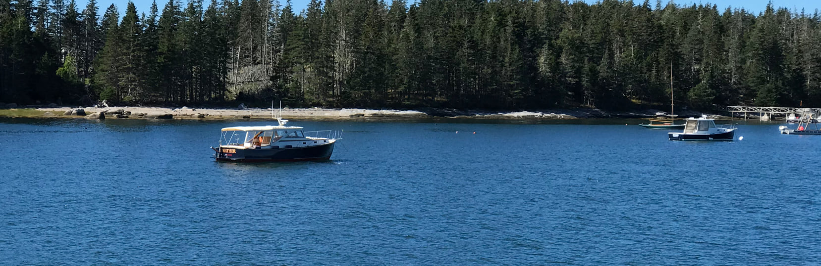
Hathor at anchor in Merchant Harbor
 Leaving Merchant Harbor, we headed for Little Cranberry Island through Jericho Bay (photo) via the York Narrows and the Casco Passage at a quiet ten knots, a speed that allowed us to spot and avoid pot buoys and their toggles in the beautiful, calm weather. We enjoyed the beautiful sight of the mountains of Mount Desert looming larger—first on the horizon, then to port as we passed across the bar in front of Bass Harbor Light, and lastly ahead as we made our way into the Western Way. We arrived in the harbor of Little Cranberry Island, where we took up a vacant working-boat mooring. Its pennant was stubby, so we ran a bridle through one bow chock, through the loop on the pennant, and back through the other bow chock, using the forward docking line.
At Little Cranberry, we enjoyed one last stroll ashore on a Maine out island, walking past the village to a long rocky beach and enjoying views to the quiet side of Mount Desert on the way back. The morning lobster boat traffic started out of the harbor, beginning at 0500—no effort to avoid making wake!

View of mountains on the quiet side of Mount Desert Island from Islesford on Little Cranberry Island
Day 5: In the morning after an early breakfast we finished packing our personal effects and cleaning the galley and head; we then went for a cruise up Somes Sound to Valley Cove. We went into Northeast Harbor to fill the boat’s water and fuel tanks at Clifton’s Dock, where there were several people ready to catch any errant arrival. We used the town landing further in the harbor to wash down the exterior of the boat. We made our way back to Southwest Harbor at a gentle six knots to avoid splashing on our gleaming vessel in time to turn the boat in by noon.

Classic yacht Enticer, touring Somes sound.
Sightings on the water: Along the way, we had seen many boats, large and small, power and sail, pleasure and working, new and traditional. We sighted a half-dozen eagles migrating; other bird sightings included eider ducks, cormorants, and guillemots. In the water, we saw solitary harbor seals and groups of porpoises.
Life aboard Hathor: We provided our own ice for the counter-top chest, bought a 2.5-gallon dispenser jug of drinking water, and brought a USB adapter for the 12-volt system (like that of an automobile) to charge our devices. Ample bedding, towels, and cleaning supplies were already on board. We loved the VacuFlushTM marine toilet in the head, which was extremely efficient, compared with other marine toilets!
The captain’s chair on the starboard side and the corresponding one on the port side adjust up and down and forward and back, and the backflips to face forward or back. This allows flexibility of use under the shelter to create a bed or settee. We set up a dining area behind the captain’s chair (when lowered and facing aft as seen in slideshow photo) and a bed on the port side with the chair down and facing aft (photo in slideshow).
The tender/dinghy arrangement had pluses and minuses. On the plus side, the electric davit quickly raised it out of the water, while swinging the engine from the tender’s transom. On the minus side, the latches that attach the tender are finger hazards. The dinghy is too small to row with anyone else aboard—it barely fits four passengers. The outboard motor is quite heavy, so it’s not a good idea to get stranded on a beach unless you have four strong people to move the boat down to the water. The tender also blocks the rearview to spot overtaking vessels. While in harbor, we lowered the dinghy enough to enjoy the view over the stern.
As a sailor, I missed having the air in my hair and the ability to take a picture in any direction from the helm that a sailboat afforded me, but the warmth and dryness of the Hathor’s shelter in bad weather was ample compensation for this. I look forward to returning to Hathor or one of her sisters for another cruise. We also appreciated very much the attention that we received from Shane Ellis, regarding some technical issues that occurred.
Some seamanship tips:
• Learn how to plot a route on the chart plotter. It will make life much easier in reduced visibility. You may be surprised to find the magenta line that you plotted running over an obstacle that you neglected to notice in setting the route, so pay attention and adjust!
• Learn how to use the radar in good visibility, so that you can identify what buoys, boats, and other targets look like in the display vs. on the water, in case you have to use the radar in poor visibility.
• Identify a cruising speed that has your preferred tradeoff between trip time and engine noise. I found ten knots to be good for passing through scenic areas and fifteen knots good for crossing open water. Be mindful that slower speeds increase the chance that the line cutter might encounter a line in the water leading to a lobster pot buoy or toggle and cause a loss of gear to the lobsterman.
• Learn the RPMs that correspond to 5, 10, and 15 knots so that you’ll know how to adjust the throttle to converge on the target speed.
• Learn to use the shift lever to nudge the boat forward or back and stop the boat with the throttle at idle—a necessary skill for docking, anchoring, and picking up moorings. Also, get to know those side-thrusters!
• In heavy weather, experiment with the boat to identify a safe speed in each direction with respect to the waves. I found that spray over the bow was a limiting factor, going into choppy seas.
• In fog, slow down to make any encounter on the water easier to react to; monitor the radar for other vessels; turn on the searchlight so that your vessel is visible to others coming in the opposite direction; and keep your eyes on the water ahead, looking for traffic, pot buoys, or flotsam.
• Anchor with care, knowing that dragging and swinging are hazards that change with the state of the tide. Know what scope is appropriate for the weather and the available space in the harbor, both for high and low tide.
• Try some wet landings on uninhabited islands, setting up the dinghy to stay in the water even at low tide, while secured via a long line to a reliable anchor or object onshore. Remember to put the motor on shallow-water mode for coming ashore.
• Be prepared to improvise, as when a mooring pennant is too large to use—think of the docking line to make a bridle.
Story and Photos provided by Stephen Flanders – September 2020